About Barangay gaulan
Historical Background
The municipality of Diplahan acquired existence upon the passage of Batas Pambansa No. 48, signed by then President Ferdinand E. Marcos, on December 19, 1979 from parts of Buug, Malangas and Siay.
Nowadays, Diplahan is composed of 22 barangays, one of which is Barangay Gaulan. Barangay Gaulan was a part of Buug before Diplahan was proclaimed as a municipality. Barangay Gaulan was named from a native bamboo tree called “Gaulan” which was abundant in that area.
Geography and Climate
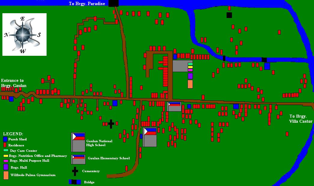
Barangay Gaulan is a rural community located at the southern boundary of Diplahan. On the North, it is bounded by Barangay Tuno, by Barangay Guitom on the East, bounded by Barangay Paradise on the West, and by Barangay Villa Castor on the South.
With a total land area of 1780 square kilometers, 1260 square kilometers are classified as low lands and 520 square kilometers as forest area. Most of the agricultural land area is devoted to crop production, the biggest share of which is used as rice fields. Corn and other crops are also farmed in the barangay, which serve as the staple food among local residents. There are also small coconut and rubber plantations in the barangay.
The climate is tropical and maritime. It is characterized by relatively high temperature, high humidity and abundant rainfall. Based on the Modified Coronas Classification, seasons are not very pronounced in the area; it is relatively dry from March to May and predominantly wet during the rest of the year. Thus, this makes the barangay very desirable for agricultural enterprises.
Population
According to the Diplahan Planning and Development Office (2009), Barangay Gaulan has a total population of 1320 with 280 households with an average of 5 living in together under one household. Among the total population of the barangay, 52% are males and 48% are females. This population is roughly 4.71% of the 28, 010 total population of the entire Municipality of Diplahan.
The barangay is politically divided into 7 puroks, suitably designated to specific barangay kagawads for purposes of easy information dissemination.
Home and Environment
According to the Diplahan Planning and Development Office (2009), Barangay Gaulan is a rural barangay in the municipality. Around 95% of the houses and 87% of the lots in the community are owned while the rest are either rented or rent – free. Majority of the houses are made with a combination of light materials, wood and concrete. It is a clear illustration of a rural community wherein much of the land is devoted to agriculture.
Political
Barangay Gaulan, like any other barangay in the Philippines, has a barangay captain/chairman as the head. The current barangay captain is Hon. Ramil Labang together with his seven (7) barangay kagawads. Each of these Barangay Kagawads is designated as head of each of the seven (7) puroks for the purpose of providing the community an access to information regarding the services, programs, projects and activities of the national government. The barangay also has its own Sangguniang Kabataan, as mandated by law, with Hon. Survivor Labang as the chairman. The barangay has several barangay tanods who maintain the peace and order in the barangay especially during occassions such as fiestas.
Economic
Of the total working population, 86% is involved in farming, 4% are sari-sari store owners, and the rest are involved in various other occupations. Their economic resources are from harvested grains from the rice fields. Like other barangays in the municipality, challenges such as lack of irrigation and pest control still exist amidst the abundance of natural resources.
Education
The barangay has a day care center, an elementary school and a high school. Most of the students of these schools are from the barangay. High school students from other barangays attend school at Gaulan National High School since it is the nearest high school in the area.
The municipality of Diplahan acquired existence upon the passage of Batas Pambansa No. 48, signed by then President Ferdinand E. Marcos, on December 19, 1979 from parts of Buug, Malangas and Siay.
Nowadays, Diplahan is composed of 22 barangays, one of which is Barangay Gaulan. Barangay Gaulan was a part of Buug before Diplahan was proclaimed as a municipality. Barangay Gaulan was named from a native bamboo tree called “Gaulan” which was abundant in that area.
Geography and Climate
Barangay Gaulan is a rural community located at the southern boundary of Diplahan. On the North, it is bounded by Barangay Tuno, by Barangay Guitom on the East, bounded by Barangay Paradise on the West, and by Barangay Villa Castor on the South.
With a total land area of 1780 square kilometers, 1260 square kilometers are classified as low lands and 520 square kilometers as forest area. Most of the agricultural land area is devoted to crop production, the biggest share of which is used as rice fields. Corn and other crops are also farmed in the barangay, which serve as the staple food among local residents. There are also small coconut and rubber plantations in the barangay.
The climate is tropical and maritime. It is characterized by relatively high temperature, high humidity and abundant rainfall. Based on the Modified Coronas Classification, seasons are not very pronounced in the area; it is relatively dry from March to May and predominantly wet during the rest of the year. Thus, this makes the barangay very desirable for agricultural enterprises.
Population
According to the Diplahan Planning and Development Office (2009), Barangay Gaulan has a total population of 1320 with 280 households with an average of 5 living in together under one household. Among the total population of the barangay, 52% are males and 48% are females. This population is roughly 4.71% of the 28, 010 total population of the entire Municipality of Diplahan.
The barangay is politically divided into 7 puroks, suitably designated to specific barangay kagawads for purposes of easy information dissemination.
Home and Environment
According to the Diplahan Planning and Development Office (2009), Barangay Gaulan is a rural barangay in the municipality. Around 95% of the houses and 87% of the lots in the community are owned while the rest are either rented or rent – free. Majority of the houses are made with a combination of light materials, wood and concrete. It is a clear illustration of a rural community wherein much of the land is devoted to agriculture.
Political
Barangay Gaulan, like any other barangay in the Philippines, has a barangay captain/chairman as the head. The current barangay captain is Hon. Ramil Labang together with his seven (7) barangay kagawads. Each of these Barangay Kagawads is designated as head of each of the seven (7) puroks for the purpose of providing the community an access to information regarding the services, programs, projects and activities of the national government. The barangay also has its own Sangguniang Kabataan, as mandated by law, with Hon. Survivor Labang as the chairman. The barangay has several barangay tanods who maintain the peace and order in the barangay especially during occassions such as fiestas.
Economic
Of the total working population, 86% is involved in farming, 4% are sari-sari store owners, and the rest are involved in various other occupations. Their economic resources are from harvested grains from the rice fields. Like other barangays in the municipality, challenges such as lack of irrigation and pest control still exist amidst the abundance of natural resources.
Education
The barangay has a day care center, an elementary school and a high school. Most of the students of these schools are from the barangay. High school students from other barangays attend school at Gaulan National High School since it is the nearest high school in the area.
Spot map of barangay gaulan